Details
- Date: Saturday, June 17th, 2023
- Meet Up: Parking lot on the east side of Lion's Park in Grangeville @ 7:30am
- Trailhead: 9:00am
- Contact: Todd Holcomb
Phone: 208-704-9739
Email: todd@clearwatertrekking.com
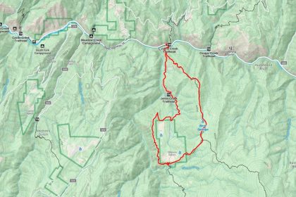
Map
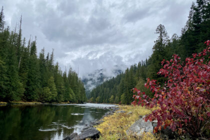
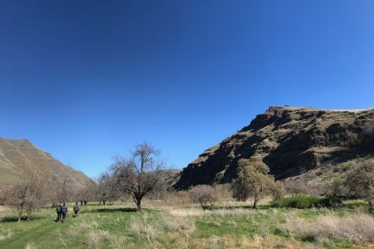
I have been wanting to explore the Slate Creek area ever since driving through it once back in 2013. Now's our chance! The plan is to set out from the Rocky Bluff Campground area on the Grangeville Salmon Rd #221 at 9:00am on Saturday, June 17th. The Forest Service webpage describes this campground as "four campsites with parking, picnic tables, fire rings and a trailhead marking a trail which skirts the edge of the Wilderness."
That's us, skirtin' the edge of the wilderness!
We will follow Slate Creek by way of Rocky Bluff Trail #331 and Hump Trail #313 for 5.5 miles up to Slate Lake. It’s a long stretch through the trees with a gradual elevation gain of about 1,600 ft. The information we have from fellow hikers and past reports is that this trail is mostly wooded with a few open meadows. There is some saturated ground and a few creek crossings, but nothing too difficult. (Just remember to bring dry shoes or sandals for the drive home.)
One thing to note is that there doesn’t appear to have been any trail maintenance out here for the past few years at least, so we may encounter downfall and thick undergrowth. We’ll go as far as we can until the trail becomes impassable or simply no fun. If we get turned back early, we can always drive up to Gospel Peak and look around or head out to the Northfork Slate Creek Trail and give that a go. The world is our oyster, right?
Wear shoes that can get wet. Pack dry shoes for the drive home. Currently, Accuweather is calling for 70F and cloudy, which sound kinda perfect, but It’s Idaho so that could turn into full-on rain or blistering sun. Keep your eye on the weather and pack accordingly. Bring a water filter, too, since we’ll be following the creek. Pack a lunch and some trail snacks. Dog treats, too, if you want to make some furry friends.
If you’re coming in from the north, through Grangeville, follow these directions to the trailhead (courtesy of Mary Aegerter on Hikingfromhere.com):
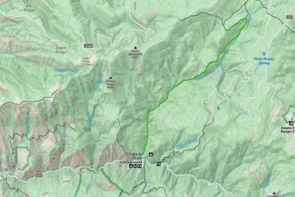
Directions from Grangeville: Turn right at the sign for Snowhaven on Road 221 after driving through Grangeville, then go straight on the same road at the drive-in-theater screen about 1 mile later. Stay on 221 for 41.2 miles and turn left on Road 444 into the Gospel Hump just before milepost 30. The Slate Lake trailhead is signed on the right, 1.6 miles up this road.
If you’re coming from the south, through Riggins, follow these directions to the trailhead (courtesy of the Forest Service):
Directions from Riggins: 19 miles up Slate Creek Road #354 from its junction with Highway 95 (1/2 mile north of Slate Creek Ranger Station) to its junction with the Grangeville Salmon Road #221, then one mile in an easterly direction to the campground access at the bridge crossing Slate Creek.
Some helpful links to learn more about the trail:
- Mary Aegerter’s description of the trail: https://hikingfromhere.com/hikes/09/slate_lake.html?fbclid=IwAR0DMTrNTLtaYJgmN5wkMphjR5RuXdCjA64ImbDzOxWKgVo9Cr-JfPdgZPo
- Forest Service Page for Rocky Bluff Campground: https://www.fs.usda.gov/recarea/nezperceclearwater/recarea/?recid=16772
- Gaiagps Maps Route of our hike: https://www.gaiagps.com/public/m1mWlhXXJHRsjR67bKAowvJE
- Accuweather report for Slate Creek: https://www.accuweather.com/en/us/slate-creek/83554/june-weather/2227207
- Google Map Directions from Lewiston: https://goo.gl/maps/tgVdXdLSSZVsUecP7
- Google Map Directions from Riggins: https://goo.gl/maps/L8QfXaaRjxAUSmKt8
- Forest Service Topo Maps of the trail:
- Dairy Mountain: https://data.fs.usda.gov/geodata/rastergateway/data3/45116/fstopo/Dairy_Mountain_453711600_FSTopo.pdf
- Sourdough Peak: https://data.fs.usda.gov/geodata/rastergateway/data3/45116/fstopo/Dairy_Mountain_453711600_FSTopo.pdf
- Hanover Mountain: https://data.fs.usda.gov/geodata/rastergateway/data3/45115/fstopo/Hanover_Mountain_453011552_FSTopo.pdf
- Florence: https://data.fs.usda.gov/geodata/rastergateway/data3/45116/fstopo/Florence_453011600_FSTopo.pdf